
Karten von Attika in the Era of Digital Humanities
Based on the unsurpassed cartographic feat by E. Curtius and A. Kaupert, this project of the Dipylon Society aims at the creation of a webGIS platform for the archaeology of Attica by overlaying multiple layers of geospatial data on a unified digital map. The content of the platform is bilingual (English-Greek) and open access. The project is supported throughout its duration by the German Archaeological Institute.
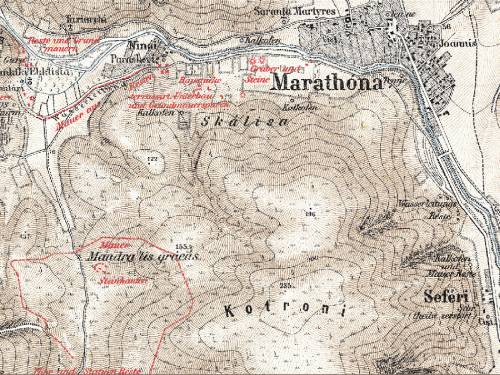
The two German intellectuals depicted with astonishing accuracy in 26 cartographic sheets the land of Attica and the antiquities that were visible at the end of the 19th century. It took almost 20 years to complete this monumental project entitled Karten von Attika. With the use of state-of-the-art technology, the cartographic sheets were georeferenced and merged, and all markings (ancient and modern remains) were digitized. Cartographic data was entered into a database to facilitate search.
Dr. Dimosthenis Donos translated the accompanying text, Erläuternder Text zu den Karten von Attika written by A.Milchhöfer, E.Curtius and G. Von Alten. The text is 263 oversize pages long and is extremely rich in information and details on the Attic landscape and the depicted antiquities. Extracts from the text were connected with specific locations on the map and with selected visual resources.
At a later stage of the project, the Dipylon research team collaborated with the German Archaeological Institute at Athens to integrate the Institute’s digital collection of pottery sherds into the platform. These potsherds originate from the surface survey conducted by Walther Wrede and Curt Gebauer in Attica between the years 1921 and 1944. The pottery sherds of this research are published in the Objektdatabank iDAI (Arachne). Furthermore, in collaboration with Professor Alain Duplouy (Université Paris 1 Panthéon-Sorbonne), data from the Lands of Meaning project have been integrated into the platform. This project explores ancient Attica as a dynamic space where social identities and settlement patterns evolved between 1200 and 480 BCE. Through digital tools such as GIS, it offers a fresh spatial perspective on phenomena such as the emergence of citizenship and the formation of local communities.
The project ''Karten von Attika in the Era of Digital Humanities'' is still in progress and continues to evolve. The next development phase focuses on the vectorization and spatial integration of natural landscape features, such as rivers, streams, and ravines, as they appear in the 24 original topographic sheets. The inclusion of these elements will significantly enhance the multidimensional reading of the Attic landscape, allowing for deeper insight into how archaeological remains interacted with natural features and offering a more holistic tool for the historical and spatial interpretation of Attica across time.
The project is implemented in collaboration with Sylvian Fachard (University of Lausanne and Swiss School of Archaeology in Greece), with the generous support of the John S. Latsis Public Benefit Foundation, the George Vergottis Memorial Fund, the J. F. Costopoulos Foundation and the Loeb Classical Library Foundation.
SPONSORS